
By: Kevin Powell, EverGRO FS Territory Sales Manager
Over the years, I’ve received a lot of questions about determining the size of growers’ fields—specifically, how to accurately measure acres and calculate the correct amount of fertilizer needed. There are several tools available for this, ranging from basic options like Google Earth to more advanced platforms like FieldAlytics, which is what we use. Another resource is your local Farm Service Agency (FSA) office, where they can pull up field acreages for you.
The first thing to understand is that when you draw or drive the boundary of a field, you’re measuring a two-dimensional (2D) surface. This doesn’t account for elevation changes. For instance, a perfectly flat 20-acre field will indeed be 20 acres. However, very few fields are truly flat. In hilly or rolling terrain, the actual surface area is greater due to the slopes and contours. Because of this, we typically recommend increasing your acreage estimate by 2–5% when ordering product. That means a 20-acre field may actually require enough input for about 21 acres.
It’s also important to consider equipment limitations. Fertilizer spreaders often don’t have boom or row shutoffs, which can lead to overlap — especially in fields with irregular shapes or angles. Perfectly square fields with irregular shapes or angles. Perfectly square fields are rare, and this overlap adds up, affecting the total amount of product used.
That’s why having accurate field maps and location data is so important. Anytime you ask me—or one of my colleagues—about a field, our first question is always: Do we have your farm mapped and current? Here’s why we ask:
- Accurate orders: Ensures we send the right amount of product.
- Field Access: Helps to identify the correct entrance points.
- Hazard Awareness: Allows us to avoid obstacles — equipment is expensive, and we want to avoid damaging it.
- New Applicators: Not everyone has been to your farm before. We rely on map-based systems. Directions like “by the red barn next to the pond near the old oak tree”, might work locally, but there are a lot of red barns out there.
- Application Efficiency: Precise mapping reduces the risk of under- or over-applying fertilizer and crop protectants. Underapplying, in particular, often ends up costing more in lost yield and pest control over time.
Below are a couple of real-world examples showing mapped field boundaries and the impact of elevation on acreage calculations. These visuals help illustrate why you should never rely solely on 2D estimates.
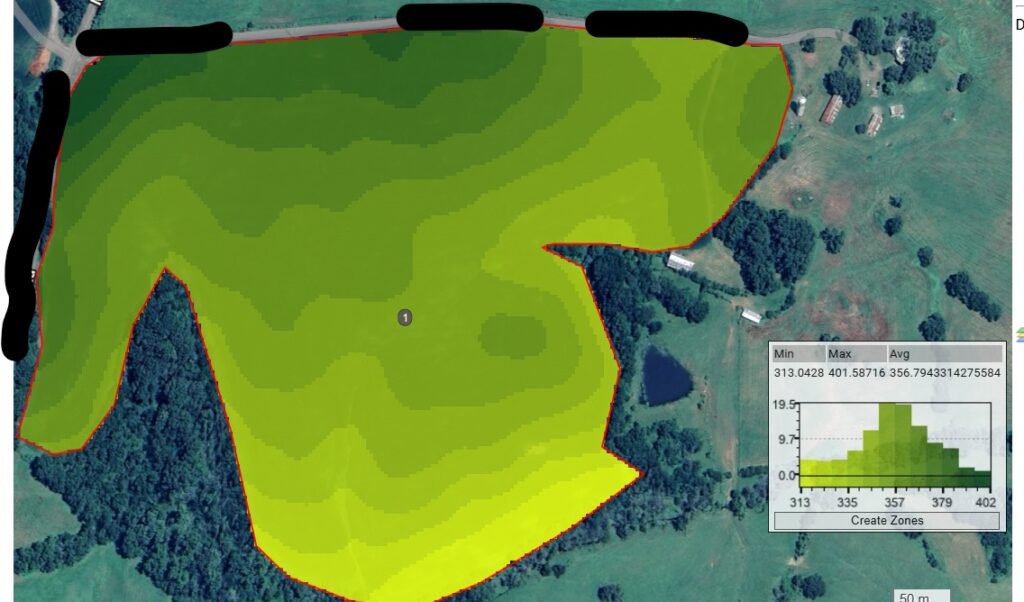
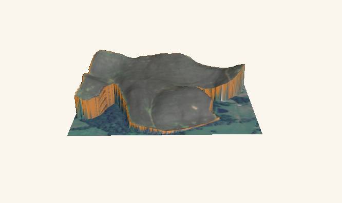
These examples make it easy to see how a field’s slope can add significant acreage that needs to be accounted for when ordering and applying product.
Final Thoughts
Accurate field mapping isn’t just a nice-to-have—it’s critical for precise application, efficiency, and cost control. If you’re unsure whether your fields are up to date in our system, or if you’d like help reviewing your acreage, please don’t hesitate to reach out with questions. We’re here to help ensure every application is done right the first time. Click here to contact us.
To stay up-to-date on agronomy at EverGRO FS and for more helpful tips, like and follow Kevin’s Travels on Facebook today!